
Tierra del Fuego – a place that immediately conjures images of untouched nature and adventure. We spent two weeks on South America's largest island and took the opportunity to explore some of the most fascinating hikes on Tierra del Fuego. From breathtaking coastal trails to majestic mountain peaks, this region offers a variety of hiking experiences for every taste and fitness level.
In this article, we present our five favorites in and around Tierra del Fuego National Park.
Summit Tour Cerro Guanaco – the Best View Over Tierra del Fuego
Cerro Guanaco is a summit tour in Tierra del Fuego National Park. Since the weather forecast predicts perfect weather with clear skies and sunshine, we tackle this tour as the first of the hikes around Ushuaia, Tierra del Fuego.
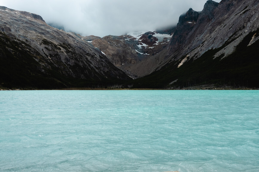
The hike starts in Tierra del Fuego National Park at the picturesque Lago Roca, where we park our car. It is a wonderful morning. The lake glimmers like a mirror in bright turquoise. It is completely windless this morning.
Along the lake (2 kilometers)
The first two kilometers are completely flat, running through the forest along the lakeshore. Here, you can once again enjoy the view of the lake before the ascent to the summit begins.
Ascent to the marshy terrain (3 kilometers)
After the first two flat kilometers, the trail turns to the right. The first partly steep ascent begins. For 3 kilometers, the trail climbs uphill through the forest. The path is mostly stepped, making it very strenuous in places.
Mainly flat across marshy terrain (1 kilometer)
After 5 kilometers, the trail levels out. It leads out of the forest into marshy terrain. The ground is damp, sometimes muddy. In some places, you must carefully find your way to avoid sinking up to your ankles. Here, you can also find the occasional log to enjoy a snack in the sun and recharge before the steep climb to the summit.
Ascent to the summit (1 kilometer)
Once you've navigated your way through the marsh, the trail continues steadily uphill over a scree field. The incline is challenging at times. For me, it's the first hike in a while, and I can definitely feel it in my legs. However, the views of the snow-capped mountain peaks and breathtaking sea and island landscapes more than make up for the burning legs. Upon reaching the summit of Cerro Guanaco, you are rewarded with a spectacular 360-degree panorama over Tierra del Fuego, the neighboring islands, and mountain ranges.
Tour Data Overview
Tour Data: 14 km (round trip), elevation gain: 920 meters
Route: here is the link to our route on Komoot
Good to know: There are only a few spots where you can refill water.


Laguna Esmeralda – the Tourist Favorite
The hike to Laguna Esmeralda is one of the most popular hikes around Ushuaia, Tierra del Fuego. Only a slight elevation gain needs to be overcome, which is almost evenly distributed throughout the hike. With a length of 9 kilometers, it is also relatively short, and the paths are consistently easy to walk and well-marked. Not only is the lagoon itself beautiful, but the trail also follows an impressive turquoise river in many parts, making the 4.5-kilometer ascent to Laguna Esmeralda enjoyable.


Tour Data Overview
Tour Data: 9 km (round trip), elevation gain: 170 meters
Route: here is the link to our route on Komoot
Good to know: It is probably the most popular hike in the Ushuaia area. To avoid the crowds of tourists, it's best to start very early in the morning or choose a day with more variable weather.
Vinciguerra Glacier – A Glacier Up Close
You've always wanted to get up close to a glacier? Then the hike to Laguna los Tempanos and the Vinciguerra Glacier might be just right for you. In an 11-kilometer round trip, this hike takes you directly to the tongue of the Vinciguerra Glacier.
Along the river (2 kilometers)
Gently, the river winds through lush green meadows, dotted with sunny yellow buttercups. In some places, we see more yellow than green. It is an idyllic scene that unfolds before us. The hike to the lagoon and glacier follows a completely flat path along the river for the first two kilometers.
Ascent to the Lagoon and Glacier (2.5 kilometers)
For over 2 kilometers, the trail leads up to the lagoon and glacier. Steeper sections alternate regularly with flatter ones. The path is marked by many roots and quite a bit of mud. Watch your step! This hike remains in our memory as the muddiest hike in Tierra del Fuego.
Final Ascent to the Lagoon and Path to the Glacier (1 kilometer)
For 0.5 kilometers, the trail ascends steeply. We reach the lagoon over a scree field, finally leaving the mud behind. Once at the top, the turquoise shimmer of Laguna los Tempanos greets us, making us forget the climb.
This is where most tour descriptions end. However, if you make your way across the small stream, you can hike along the right bank directly to the Vinciguerra Glacier. Within a kilometer, you can reach the glacier tongue.
Tour Data Overview
Tour Data: 11.3 km (round trip), elevation gain: 580 meters
Route: here is the link to our route on Komoot
Good to know: Perhaps it was just a coincidence, but it was the muddiest hike we did in Tierra del Fuego. Good footwear is essential, if only to avoid slipping and keep your feet dry.


Jimbo Ice Cave and Laguna del Caminante
Update 2025: Unfortunately, the ice cave has collapsed this year. The hike is still beautiful and worth it, but without the ice cave, a definite highlight of the trek is missing.
An absolute highlight in Tierra del Fuego is this hike to the Jimbo Ice Cave and Laguna del Caminante. At 25 km, it is the longest day hike we did in Tierra del Fuego. However, it is our absolute favorite of the 5 hikes around Ushuaia. If you have no concerns about the distance, we highly recommend this tour.
Starting Point and First Ascent (6 kilometers)
We start the tour in the reverse direction from how it is officially advertised. After the first few gently sloping kilometers, the trail steeply ascends over a scree field. The steep part of the ascent is only about 800 meters long, but it is quite challenging. The path is narrow, sometimes very steep, but manageable.
Along the mountainside with spectacular views (2 kilometers)
After completing the initial steep ascent, the trail levels out again. For 2 kilometers, the path runs mostly flat along the mountainside. The view throughout is spectacular.
Ascent to the Jimbo Ice Cave (2 kilometers)
The ice cave itself is not an official part of the hike. After the flat 2 kilometers, the trail turns left toward the cave. It’s easiest to follow the route on Komoot, for example. However, if you pay attention, you can also spot the cave from the trail.
The detour to the cave is about 3 km long. For approximately 1 km, the path ascends steeply to the cave and then levels out. Entering the cave is not permitted, and you should adhere to this rule. At regular intervals, you can hear and see smaller and larger rocks and ice chunks falling. However, the view from the outside is also breathtaking.
From the cave to the pass and the junction to Laguna del Caminante (2.5 kilometers)
Once you return from the cave to the main trail of the hike, a short, steep ascent leads to the pass. From here, a continuous ascent begins, mostly descending gently over a scree field.
Junction to Laguna del Caminante (2.5 kilometers)
The path to Laguna del Caminante branches off to the left from the route. After a short but steep climb, you can see the lagoon from above. You can either be satisfied with the view from above or start the descent. The path is narrow, very stepped, and has many large boulders that can be particularly slippery when wet.
From the lagoon, you need to take the same route back to the main trail.
Return through the forest (10 kilometers)
The last 10 km of the hike mostly run flat through the forest. The landscape changes very little. It's tough, and we can feel the kilometers and elevation gain we have already covered in our legs. Especially the final 6 km feel quite long.
Tour Data Overview
Tour Data: 25,4 km (round trip), elevation gain: 980 meters
Route: here is the link to our route on Komoot
Good to know: The tour is not a complete loop. The start and end points are not exactly at the same location. Since we drove our own car to the starting point, we need to call a taxi at the end. However, there is no mobile reception at the end of the hike. Therefore, we have to walk about 2 km along the road until we can finally call a taxi. You should plan for this.


Martial Glacier Out and Back
The hike up to Martial Glacier served as our introductory hike. It is not particularly challenging, yet it offers a wonderful view of Ushuaia. Among all the hikes around Ushuaia, Tierra del Fuego, it is especially suitable for those with limited time who still want to enjoy a great view of Ushuaia and the harbor.
Tour Data Overview
Tour Data: 6 km (round trip), elevation gain: 440 meters
Route: here is the link to our route on Komoot
Good to know: The tour offers a very nice view of Ushuaia and the harbor. Due to its short length, it can be easily completed in the morning or afternoon, making it suitable for a day with variable weather. It starts close to the center and can therefore be easily combined with a visit to Ushuaia.
2 Comments
Danke für die Wanderungen, Nummer 1 hat uns am Besten gefallen 🙂
Wollten morgen zur Eishöhle, aber laut einem Kommentar auf Google Maps (dort ist die Höhle unter Cueva de Hielo del Cañadón de la Oveja verlinkt), existiert die Höhle nicht mehr, da sie Januar 2025 eingestürzt sei.
Hi, danke für deine Rückmeldung. Das scheint wohl zu stimmen. Wie schade! Es ist trotzdem eine sehr schöne Wanderung, die Aussicht und die Lagunen lohnen sich auf jeden Fall. Aber mit der Eishöhle fehlt natürlich definitiv ein Highlight der Tour.