
The Lagunas Route in Bolivia is arguably one of the most famous overlander routes in South America. It runs from San Pedro de Atacama to Uyuni, or in its longer version, from Tupiza through the southwest to Uyuni. The Lagunas Route, also known as the Southwest Route, passes through the Eduardo Avaroa Andean Fauna National Reserve.
What is the Laguna Route in Bolivia?
The Laguna Route in Bolivia is one of the most popular destinations for tourists in Bolivia and one of the most famous overland routes in South America. The main route is traveled daily by various tour operators from Uyuni, San Pedro de Atacama, and Tupiza.
The Laguna Route constantly runs between 4000 and 5000 meters in altitude. Depending on the route chosen, it covers between 500 and 800 kilometers, with the shorter San Pedro to Uyuni route being by far the most frequented. We spent a total of 6 days traveling from San Pedro de Atacama (Chile) to Uyuni (Bolivia). Whether the route is still worth it despite the hustle and bustle and if it still lives up to its adventurous reputation, you can find out in our blog article.
From San Pedro de Atacama to the Chalviri Hot Springs
The border crossing is quickly done. Mostly tour buses and self-drivers cross the border here. In the first building, we get our exit stamps from Chile and return our TIP. A few kilometers further, we get stamped into Bolivia, and a few kilometers beyond that, we receive our TIP for Bolivia—this time in duplicate, for security reasons, if we understand the officer correctly. The officer also warns us never to let it out of our hands. This makes us a bit uneasy about future encounters with Bolivian police, or those pretending to be police. The Foreign Office warns about this. But for now, that's a problem for tomorrow. We're unlikely to encounter fake police on the Laguna Route.
We have arrived in Bolivia, the fourth country on our journey. A country we have been looking forward to for a long time. Bolivia has been on our wish list long before this trip. After 5 months, during which we became very accustomed to Argentina and Chile, it means stepping into the new again, out of the comfort zone that has so nicely settled around us. It's amazing how quickly one can adapt. But that's why we are on this journey, to step out of our comfort zone. New cultures, new customs, new currency.
Die Landschaft ist vom ersten Moment an spektakulär, die Straße bescheiden. Zu unserem Erstaunen und Freude flacht das Waschbrett ein wenig aus. Nur wenige Kilometer nach der Grenze liegt die Laguna Blanca. Ein wenig muss man von der Hauptroute wegfahren, um zu ihr zu gelangen. Wir fahren weithin Richtung Termas. Links und rechts erheben sich die Berge wie Gemälde. Wir sind bereits auf über 4000 Metern und dennoch sind die Gipfel um einiges höher. Auf dem Weg kommen wir am Dali vorbei. Man sieht es nur von Ferne. Wir dachten man fährt näher heran, aber der Weg ist versperrt. Laufen wollen wir nicht. Die Höhe zerrt an unseren Energiereserven und der Wind bläst eisig.
Gegen 16 Uhr kommen wir an den Termen an. Hier tummeln sich die Landcruiser mit ihren Turisten. Jeder will einmal ins warme Wasser. Uns ist es noch zu voll. Unsere Freunde laden uns zum Essen ein, wir sind froh einmal nicht in der Kälte kochen zu müssen. Draußen ist es inzwischen dunkel, die Sterne funkeln und der Mond taucht die Landschaft in sanftes Licht. Wir schlüpfen in die Badesachen und machen es uns im warmen Nass gemütlich. Rein ist einfach. Raus ist weniger angenehm, es hat inzwischen Minusgrade. Wir vermissen unsere Standheizung, schlüpfen schnellstmöglich in die Schlafsäcke und kommen erst bei den ersten Wärmenden Sonnenstrahlen wieder raus.


To Laguna Kollpa and Laguna Hedionda
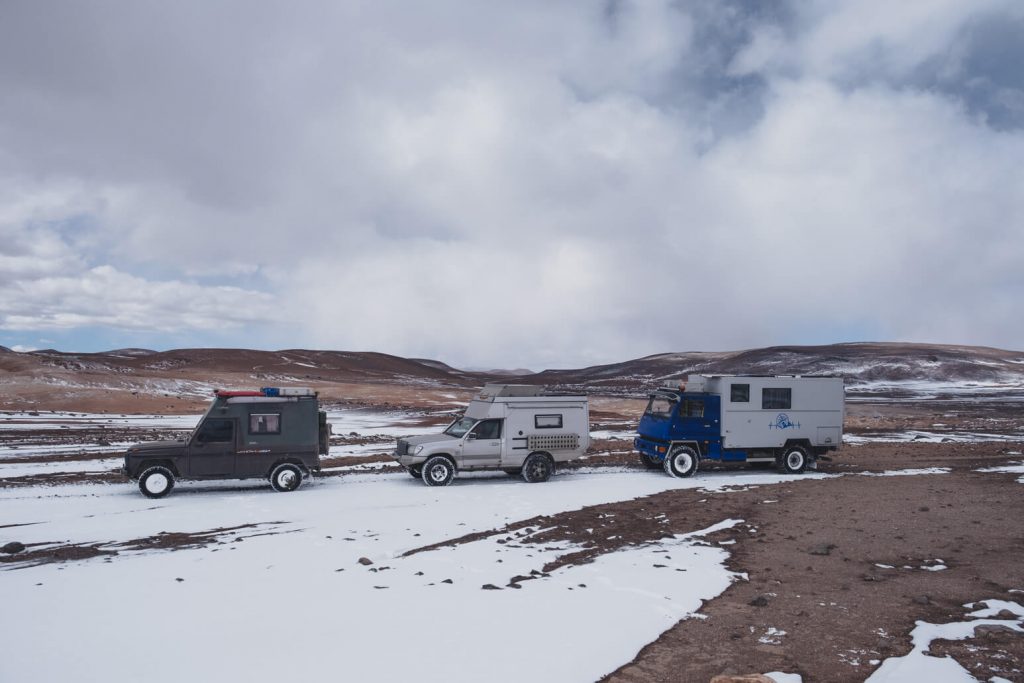
Armin and Claudia are waiting for their friends. The other Swiss couple spent another night at 3800 meters to acclimatize and plan to join us today. We don't want to park among the tourist crowds all day, so we decide to continue our journey.
The first day on the Laguna Route was a bit disappointing for us. Instead of the expected solitide, it felt more like a tourist highway. For this reason, we decide to deviate a bit from the main route and head east towards Laguna Kollpa and Laguna Hedionda. We had read somewhere that there should be many flamingos here. Before setting off, we quickly calculate our fuel and decide that it should be enough to reach Uyuni despite the detour.
The drive is quite exhausting. Although the landscape is beautiful, the track is a constant washboard, making the journey lengthy. However, we see more flamingos in these two lagoons than ever before. Since we have to take the same path back to rejoin the main route, we head back after taking some photos. We set up camp at a small lagoon just a few kilometers north of the Chalviri hot springs.


Through Snowstorms and Geysers at 5000 m to Laguna Colorada
We wake up in the middle of a snowstorm. It's cold, and the windows are covered with ice crystals. Visibility is only a few meters. There's not much snow around us, but the icy wind blows the little snow there is as snowdrifts on the road. We pack up and head back to the main route. We don't want to get stuck here.
Back on the main route, we drive a bit further. Visibility is extremely poor, and we have to navigate through several snowdrifts. Although a few tourist Landcruiser pass us in the opposite direction, indicating that the road is passable, we still feel uneasy. Our route today takes us to 5000 meters. After some discussion and deliberation, we decide to return to the hot springs and see what our Swiss friends' plan is.
Armin und Claudia im Duro möchten weiter. Die anderen beiden, die gestern erst nachgekommen sind, werden zurück nach Peru fahren. Die Nacht auf 4100 m war zu schlecht. Zwei Deutsche in einem Toyota schließen sich an. Wir fahren im 3er Gespann weiter. Um 10 fahren wir los. Es hat ein wenig aufgeklart. Gute Vorraussetzungen, um unser Glück zu versuchen. Wir müssen uns durch einige Schneeverwehungen kämpfen. Wir fahren mit dem Puch voraus. Er schlägt sich hervorragend. Wir sind unbeschwert und genießen das kleine Abenteuer. Wir wissen ja, dass der Duro uns jederzeit herausziehen könnte. Alleine wäre wir hier sicher nicht weitergefahren. Einige der Schneeverwehungen waren wirklich am oberen Limit, aber wir kämpfen uns durch und bleiben tatsächlich kein einziges Mal stecken. Auf 5000 Metern erreiche wir das Geysirfeld Sol de Mañana. Vermutlich kam uns das Schneetreiben zu gute. Es sind nur wenige Touristen hier. Nach einer kurzen Erkundung fahren wir weiter in Richtung Laguna Colorado.
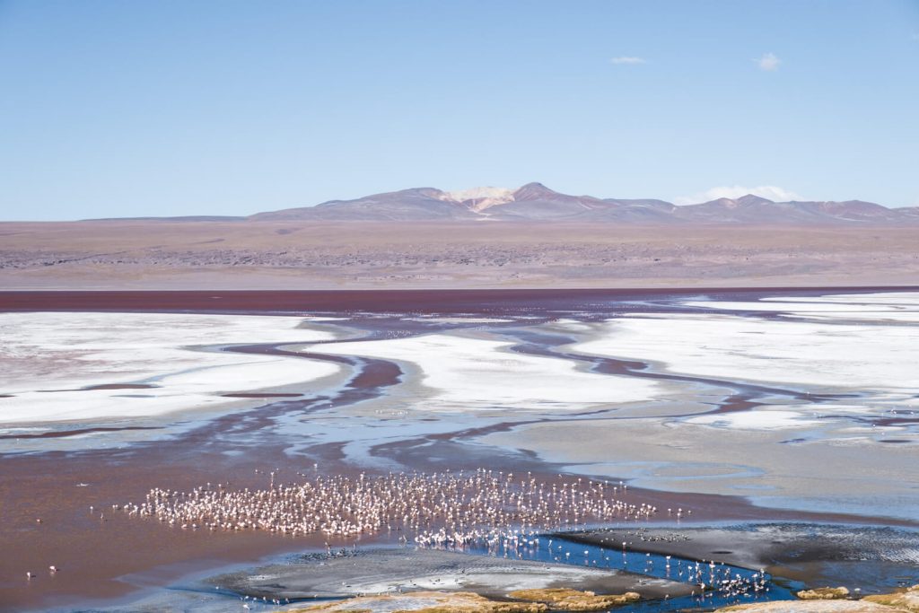
Der Schnee nimmt langsam ab. Zwar liegen immer mal wieder Schneeverwehungen auf der Strecke, aber diese lassen sich hier problemlos umfahren. Überhaupt scheint es bald keine Hauptroute mehr zu geben, sondern viele kleine. Jeder sucht sich hier seinen präferierten Weg selbst. Bald schon ist die Laguna Colorado in Sicht. Die wohl bekannteste Lagune auf der Strecke. Der Parkplatz ist gefüllt mit Landcruisern – Touranbieter aus Uyuni und Tupiza. Am Ufer der Lagune versuchen alle das perfekte Flamingo Foto zu schießen. Zu unser Verwunderung gibt es hier tatsächlich ein kleines Café. Perfekt zum Aufwärmen, allerdings fehlen dem kleinen Café die Fenster, weswegen das mit dem Aufwärmen nur so halb klappt. Wir laufen runter zur Lagune und versuchen auch noch unser perfektes Foto zu erhaschen, bevor wir einmal halb um die nLagune fahren, um an einem Aussichtspunkt unser Nachtlager aufzuschlagen.


Past the Árbol de Piedra (Rock Tree) to Laguna Kara and Laguna Honda
Die Nacht war wie immer kalt. Zum Glück kommt morgens verlässlich die Sonne raus, sodass es schnell zu warm wird in der Daunenjacke. Einige Touristen kommen vorbei, sind aber genauso schnell wieder weg. Sie haben einen straffen Zeitplan. Die Landschaft ist sandiger. Sie glitzert und leuchtet in satten Gelb- und Orangetönen in der Sonne. Unser erstes Ziel für heute ist der Árbol de Piedra (Baum aus Stein). Die etwa 7 Meter hohe Felsformation aus vulkanischem Gestein ragt etwas unwirklich aus dem Wüstensand hervor.
Von hier an führt uns unsere ausgewählte Strecke weg von der Hauptroute, weiter ins Hinterland. Die Anzahl der Landruiser nimmt rapide ab. Wir genießen die Ruhe. An de Lagune Kara machen wir unseren Mittagsstop. Es ist wunderschön. In der Sonne lässt es sich gut aushalten. Wir hätten ohne Probleme hier unser Lager aufschlagen können, aber die anderen wollen weiter. Wir kommen an einigen weiteren Lagunen vorbei, mit mal mehr mal weniger Flamingos.
In the end, we set up camp at Laguna Honda. The lagoon is small and has a little peninsula that you can drive onto, which would be the best spot for the night. However, due to the strong wind, we park the cars a bit lower, next to a small hill that provides some shelter from the wind and the cold.


Laguna Chiar Khota, Smelly Lake, and Campsite at Rio Alota
We wake up early. It's Monday, which means a workday for Mats. I want to take some photos and discover that a few flamingos have gathered overnight. It's been a few years since we saw in one of the Planet Earth episodes that the flamingos in the Altiplano lagoons freeze in the ice at night. Since they have no predators here, it's not a big deal. The next morning, they wait for the sun to free them from the ice again. I'm lucky and wake up early enough to witness this spectacle. It's fascinating and a crazy sight to see the flamingos slowly stumble out of the ice and then go about their daily routine.
After lunch, we set off again. We pass by two more lagoons with flamingos, but after seeing so many in the past few days, we feel like we've had our fill. It's amazing how quickly one can get used to things. What was new, exciting, and special just moments ago can quickly become normal.
The rest of the day, we slowly drive towards Uyuni. Along the way, we even find a paved road. We find a campsite by a small river near the Valle de Rocas (Valley of Rocks).


Detour to Valle de Rocas and Uyuni
Today, only we and the Duro continue. We want to visit the Valle de Rocas. There is a small loop that you can drive through. After a short drive, larger and smaller rock towers rise up on either side of us. As time goes on, the path through the valley becomes narrower. Eventually, it becomes too tight for the Duro, and we turn back. At least we arrive in Uyuni early and can still shop, refuel, and take a shower in peace.


Conclusion on the Laguna Route in Bolivia
The route offers breathtaking landscapes and varied impressions. While some sections are well-visited, we encountered most people and tours at the Chalviri Hot Springs and Laguna Colorada. Away from these popular attractions, one often enjoys solitude and pristine nature almost alone. For us, the Laguna Route was a highlight of our trip so far.
Our route you can find on Gaia GPS.
Useful Information about the Laguna Route in Bolivia
- What is the best time to travel the Laguna Route?
- The best time to travel the Laguna Route in Bolivia is from April to November, during the dry season. During these months, the road conditions are better, and the weather is more stable, making the journey more pleasant and safer.
- Do I need my own vehicle for the Laguna Route?
- No, you can book one or multi-day tours along the Laguna Route through various tour operators in Tupiza and Uyuni.
- Is a four-wheel-drive vehicle required?
- Not necessarily. We have heard of some people driving the route in 2WD. Whether you want to put your vehicle through that is up to each individual to decide. The road conditions can be very rough at times, and there is the uncertainty regarding weather conditions. On the second day, we wouldn't have been able to continue without four-wheel drive and would have had to wait out the snowdrifts.
- Do you need to bring food, water and fuel?
- As a self-driver, you need to bring sufficient food and water, as there are no opportunities to replenish these along the way. Fuel must be carried for the entire route, as there are no refueling stations en route.
- How much time do I need for the lagoon route?
- This varies individually and depends on whether you are taking the longer 800 km route or the shorter 500 km one. We recommend planning for at least 3 days.
- What is the road and path condition along the route?
- Often it is a washboard road, where you can only move slowly. Sometimes it is better, sometimes worse. At times, there is no clear main route, only many parallel tracks from which you can choose one.
- Is prior acclimatization necessary to prepare for the altitude?
- Depending on where you start the route, a few days should be planned for acclimatization. Since San Pedro de Atacama is at 2,500 meters, we spent two nights at a campsite at 3,850 meters before crossing the border into Bolivia.
- Is there mobile phone reception along the route?
- On the route we traveled, there was no mobile phone reception.
- Do I need an entrance ticket for the national park?
- An entrance ticket is required to visit the Eduardo Avaroa Andean Fauna National Reserve, through which the Laguna Route passes. The entrance fee is 150 Bolivianos per person (as of May 2024). The ticket can be purchased at the park entrance or in Uyuni. It is important to keep the ticket with you throughout the tour, as it will be checked at various checkpoints.
7 Comments
Vielen Dank für den sehr gut aufgebauten Bericht. Neben den Beschreibungen freue ich mich über die klaren Infos. Sie helfen bei der Planung der eigenen Tour die im Dezember 2024 in Montevideo beginnt.
Vielen lieben Dank für das nette Feedback! Es freut uns sehr, dass die Informationen hilfreich sind. Wir wünschen Ihnen weiterhin eine gute Vorbereitung und viel Vorfreude. Da liegt definitiv eine tolle Tour vor Ihnen!
Thanks for all the great information you have provided on the Laguna route. We plan on driving the Laguna route next year. I am interested in your track log. Unfortunately, when I open the Gaia GPS link I get a message saying „An error occurred while loading this sidebar.“. The route is not shown. Any thoughts on why I cannot access the route?
Thanks again for a great web site.
Geoff..
Hi again 🙂 We have updated the links. They load slow, but hopefully now they should work again also on the computer 🙂
I just discovered that the Gaia GPS link works fine on my phone but fails on my pc. I tried clearing cache, logging off and back on etc. to no avail. Not to worry. Using phone works for me.
Hi, thanks for letting us know. We get the same error message on the computer and will see if we can figure out what the problem with the link is. Good to know it works on the phone though at least for now. Wish you a really nice drive next year. It is an amazing place!!
Sarah
I checked this Gaia link and another in the Peru section and they now both work on PC and Phone. Thanks so much for fixing this.
All the best for your travels. Maybe we will see you on the road. We plan on being in Ushuaia between Christmas and New Year.
Geoff..