During our journey through the Peruvian Altiplano, we stop in Santo Tomás and consider which route to take next. When we check iOverlander, we discover a marker for a remote route that leads above 5000 meters four times. It is a detour to the Colca Canyon, which is not quite on our route, but sounds too tempting to pass up. So we decide on this exciting side trip along the 4x5000 route, one of the most impressive offroad tracks in the Andes.
Day 1: Acclimatizing at 4300 meters
From Santo Tomás, the road steadily climbs upward. We pass several small mountain villages. At an altitude of 4000 meters, the landscape flattens into a plateau. The route initially continues gently but soon climbs continuously to 5000 meters and runs almost entirely at an altitude of 4650 to 5000 meters until just before Orcopampa. Since we need to spend at least one night at this altitude but are not yet acclimatized, we decide on a short first driving day. We look for a place to stay on the plateau and find a beautiful spot with a breathtaking view of the valley. After only 35 kilometers of driving, we stop at 12 p.m. After many days of driving in the past weeks, we enjoy the relaxed afternoon, finally without driving. We use the time to cut Mats' hair, bake pizza, and bread.


Day 2: Over Passes 1&2 of the 4x5000 Route to Huacullo
On the second day, the route through the Peruvian highlands becomes more adventurous. For about three kilometers, the road is in very poor condition. Large rocks make driving difficult, and cracks run lengthwise through the road again and again. Several times I get out and prefer to walk behind, although Mats says that our Puch handles it without any problems.
Fortunately, this difficult stretch is soon behind us. Although the road doesn't really improve much afterward, it is at least more drivable. In some sections, we can even drive at a decent pace, but most of the time we have to avoid potholes and make progress at only about 20 km/h.
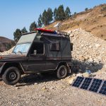
On our drive through the Peruvian highlands, we pass several small herding villages and are always amazed to see people and alpacas in this remote area. After 79 kilometers, we reach an altitude of over 5000 meters for the first time and shortly after cross the first pass of the 4x5000 Route at 5096 meters. We take the opportunity to launch the drone – a perfect moment to capture the spectacular views over the Andean highlands. Despite the altitude and wind warnings, it flies as safely as an Andean condor. Just 9 kilometers further, at kilometer 88 from Santo Tomás, we cross the second pass at 5016 meters.
Around 4 p.m., we reach the remote village of Huacullo. On the narrow, winding mountain roads, it is often difficult to find a suitable spot for the night, as the roads often run along steep slopes. By 5 p.m. at the latest, it gets bitterly cold, and at an altitude of 4700 meters, we decide to spend the night in the village.
As in most villages in the Peruvian mountains, there is a small restaurant here, and the typical dish is trout with rice and fries. The friendly owner prepares us a delicious trout and the best fries we've had in a long time – freshly made from potatoes. When we ask if we can park in the village, she invites us to park right next to her house. In the evening, half the village comes by to chat with us. Tourists are rare here, and the villagers are curious about where we come from and where we are headed. Everyone is incredibly friendly, and we feel very comfortable. We sleep surprisingly well at 4700 meters.


Tag 3: Über Pass 3 & 4 der 4×5000 Route und durch Mienen
During the night, it became heavily overcast, and a thick veil hangs over the small village of Huacullo. The windows of our vehicle are covered with thick frost patterns. Fortunately, we don't have to scrape them after all, as although the sun hasn't fully broken through yet, it's already warm enough to melt the ice from the windows.
As we set off, most of the villagers seem to still be staying in the warmth of their homes. But shortly after leaving the village, the fog clears, and the thick fog bank remains behind us.
Today we cross the next two passes on the 4x5000 Route. We reach the third pass at kilometer 130 at an altitude of 4966 meters, and the fourth pass 30 kilometers later, at kilometer 160, at an altitude of 5070 meters. Someone must have been too optimistic. The route should really be called the 3x5000 Route. Shortly after the pass, we reach the Arcata mine, through which we have to drive. A friendly security officer takes down our details—license plate, names, and passport numbers—and we are allowed to pass. The mine seems almost deserted; at least today, no one seems to be working here. After about 10 minutes, we reach the exit of the mine road, where a second security officer lets us through.
From here, it's only 10 kilometers to the village of Arcata. The road runs along a lagoon located just below the mine. I wonder what ends up in that water?
In the afternoon, we find a good spot by the river, just a few kilometers past Orcopampa. Our camp is about 100 meters off the road—not completely hidden, but not many cars pass by here anyway. We're now back under 4000 meters, with our sleeping spot at around 3700 meters altitude. It's crazy when you think that the night before we slept a whole 1000 meters higher. Peru is truly a fascinating country, especially when it comes to the extreme altitude differences.


Day 4: Through the Canco Valley to the Colca Canyon
From our campsite, it's not far to the small village of Andagua, the starting point for excursions into the Valle de los Volcanes (Valley of the Volcanoes). However, we only drive through, as we know we will take the same route back to reach the Cotahuasi Canyon.
The road steadily descends. Instead of the cold mountain air and alpacas, cacti now line the route, and hummingbirds flutter through the air. It's pleasantly warm, and we swap our sweaters for T-shirts.
Our lunch stop is in the middle of an old lava field. The surroundings feel surreal, a rocky landscape crisscrossed by ancient terraced fields. Where these fields came from and when they were abandoned remains a mystery – we couldn’t find any information about them anywhere.


To reach the Colca Canyon, we have to pass through the Canco Valley. iOverlander warns of rockfall, and the Canco Canyon is indeed a rocky valley with little vegetation. The lowest point of the route is at 1398 meters. Here, we find a small oasis with fields full of avocados and papayas. In total, we have descended over 2400 meters in altitude today. From here, the route climbs back up.
The single-lane switchback road winds its way up the canyon. It might be the most impressive canyon we've crossed on our route. At kilometer 320, we pass through the small village of Huambo, where the landscape changes once again. The rocky slopes give way to the typical terraced fields the Colca canyon is known for.


From here, the road climbs up to a pass at 4026 meters before slowly descending again. Cabanaconde, our destination for the night, is located at 3300 meters in the Colca Canyon. After confirming with the friendly police officers that we are allowed to stay overnight at the plaza, we find something to eat and go to bed early.


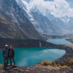
Info – Valle de los Volcanes: On our return trip towards Cotahuasi Canyon, we stopped at the Mirador Antaymarca viewpoint. A short but steep path leads up to the viewpoint, offering a breathtaking view of the Valley of the Volcanoes. The parking area is ideal for overnight stays, as it is far enough from the road and not visible from it. Additionally, it's the perfect spot to watch hummingbirds.
Route and GPX: 4x5000 Route to Colca Canyon
In Gaia, you will find our route description "4×5000 Route: Santo Tomas – Colca Canyon" as a GPX for download.